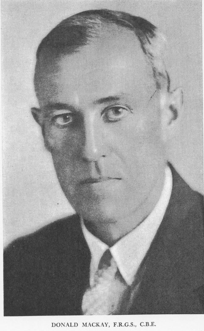
DONALD MACKAY (1870-1958)
(Australian Explorer and Pioneer Wireless User)
by Ray Robinson
Donald George Mackay was born in Yass, New South Wales, on 29
June 1870, the son of a sheep farmer on the property Wallendbeen. The population
of the six Australian colonies was 1.6 million people. He was brought
up on the property, then at age 12, was sent to Oaklands boarding school
at Mittagong. After school, Donald tried to be an engineer in Sydney, but
the city life was not for him. He became a jackaroo on his father's property.
Upon his fathers death in 1890, Donald received a comfortable inheritance.
He tried bare knuckle boxing under the tutelage of Larry Foley and Mick
Dooley in Sydney. He tried sculling with world champion Bill Beach at Dapto.
He travelled to New Zealand, Hong Kong, Japan, France, England, Italy, Germany,
Belgium, and the United States. He tried gold mining on the Wallendbeen
property, and then at Milparinka near the borders of South Australia
and Queensland. He rode a bicycle to Milparinka, through the desert.
1899 CYCLING
Arthur Richardson was a professional bicycle rider, and was riding
around Australia, trying to set a new record. It had never been done before.
Donald decided he would try and beat the record, even though the Richardson
ride was still in progress. He joined Alec and Frank White who were also
attempting the record, and were riding in the opposite direction. Donald
rode his Melbourne made Dux bicycle , up the East Coast of Australia,
from Brisbane, to Charters Towers, then through crocodile country, and
followed the new Normanton railway line, then the telegraph line to Camooweal,
pushing the bike through sand and spinifex, death adders and waterless
desert. They met a Chinaman walking from Darwin to Queensland, sneaking
across the border to avoid poll-tax. They were sunburnt, thirsty, out
of food, and suffering from dysentery. Some friendly aborigines showed them
where water was. They finally reached the new Overland Telegraph Line and
followed it North, and met Richardson, who was riding in the other direction.
They reached Darwin, but their spare tyres and tubes had not arrived by
ship. They continued West, until the tracks finally ran out. Tropical rain
turned the soil into mud, which stuck to the tyres so that the wheels would
not turn. In a gorge, they were ambushed by Aborigines throwing spears.
They drove them off with revolvers. They crossed into Western Australia
and through the Kimberly, and mended the bald tyres with green hide. They
reached Derby, and found a track to Broome, and they continued the 1,500
miles over 6 weeks to Perth. Richardson had arrived in Perth 2 days previously,
setting the first around Australia record at 243 days. Donald was determined
to beat the record, and left for Brisbane, with only 3,747 miles to ride
in 50 days! He succeeded, and lowered the 11,000 mile round Australia record
to 240 days.
1908 NEW GINEAU
Donald married Amy Isabel Little on 16 April 1902 at Homebush, and
settled down in Port Hacking NSW. However, the bicycle ride in the remote
desert and the years on the land, kindled his love of the wilderness
and exploration. Papua New Gineau, had been annexed by the colony of
Queensland in 1883, to forestall a German annexation. It was transferred
to the Commonwealth of Australia in 1906, and Donald's brother, Colonel
Kenneth Mackay was appointed chairman of a Royal Commission to inquire
into conditions there. He mentioned to Donald that much of the interior
was unexplored by white man. The Purari river had been explored upstream
for only 120 miles, but nothing further was known. Donald organised and financed
an expedition to go up the river, to map the headwaters, then return down
the Fly river. The Administrator of New Gineau approved, and the expedition
began in July 1908. The expedition consisted of 4 white men and 80 carriers.
It was the monsoon season and the river was in flood. Donald caught malaria.
They were ambushed by natives firing arrows. On 3 September, they were 120
miles up river, and had reached the farthest explored point. They continued
upriver, negotiated Hathor Gorge and discovered coal seams. Some natives
responded to gifts, others responded with flights of arrows. The country
was so rough, that they proceeded only a further 50 miles upriver in 2
months. On December the 18th, they had penetrated 100 miles into new territory,
but the maze of ranges and ravines continued, the rain was incessant,
and the natives were still unfriendly. Stores were running low, most
of the party was sick with malaria, fever, or wounds and infections, so
they turned back, and reached the sea on 20 January, after 5 months.
1911 SOUTH PACIFIC
Some Americans contacted Donald and wanted to search for the buried
treasure of Bonito the Buccaneer. Donald financed the expedition, and
purchased a yacht. They sailed to Noumea, then Tanna, and dug holes in many
locations, but no treasure was ever found.
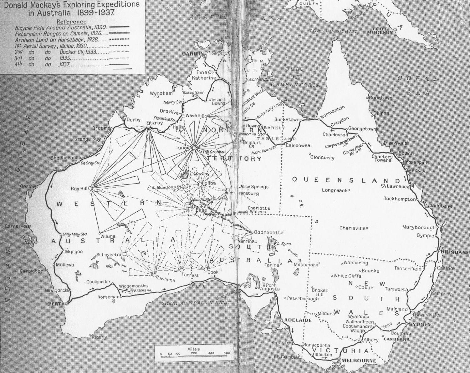
1926 PETERMANN RANGES
Donald decided to explore the Petermann Ranges. Parts of Central
Australia had been crossed by many explorers, Giles, Gosse, Tietkans,
Lindsay, and George, but many areas were still blank on the map. On
28th of May 1926, he left Charlotte Waters, with Dr. Herbert Basedow
(geologist and anthropologist), H. Oliffe with 30 camels, Frank Feast
who was the cook, and 2 aborigines, named Sambo and Ronald. Donald purchased
a 9 valve superheterodyne wireless receiving set, to receive time signals
for calculating their position. Latitude can be found with a sextant, by
measuring the elevation of the sun at noon, but longitude needs an accurate
time source, to determine their position from the zero degree meridian of
Greenwich. They travelled l,300 miles West to Ayres Rock and the Olgas, and
reached Blood Range for Donald's 56th birthday. They turned South and explored
the Petermann Ranges, the first white men to do so, then travelled to the
Musgrave ranges, and returned to Oodnadatta on 13th of August.
1928 ARNHEMLAND
Arnhemland also had blank parts on the map. The explorers Leichhardt,
Gregory, McKinlay, and Lindsay, had crossed the area but had never
accurately mapped it. The politics of the 1920s was claiming "A million
farms for a million farmers" to encourage immigration to Australia,
but the dry interior was unsuitable for agriculture. However, Arnhemland
had plenty of rain! Mackay organised an expedition, and financed it.
He found Arnhemland also had plenty of swamps, marshes and flooded rivers,
that it was dry one season, and a swamp the next, but hot all year round.
They went to Darwin by ship, then by train to Katherine River. The expedition
started on 18 April 1928, with Dr. Herbert Basedow and Frank Feast, Walter
H. B. Sully (cinematographer), 2 aboriginal trackers, Barney and Deacon,
and Larry Coonan with 27 horses and 7 mules. They headed West to Mataranka,
then to Roper River, then North following the Wilton River. On 20th May
they reached the coastal swamps, then turned West, crossed some hard ground,
then more swamp. A pack mule rolled over on its pack, then bolted, throwing
the pack. The pack contained the expensive 9 valve superheterodyne receiver
and battery. The receiver still worked, and received the time signals,
necessary to calculate longitude. They continued through broken stony
country and finally made contact with the local tribes. The expedition
eventually reached open plains and arrived at the Oenpelli mission, then
on to the East Alligator River, and to the railway line at Pine Creek.
They had travelled 700 miles in 2 months and 2 days.
1930 NORTHERN TERRITORY
During his previous exploration of the Petermann Ranges, he had wondered
what was beyond the horizon. From camel back, he could only see a few
miles either side of their track. He decided he would revisit the area,
but with the modern invention of the aeroplane, which would allow him
to see many miles and travel much faster than the camel speed of 2.5 miles
per hour.
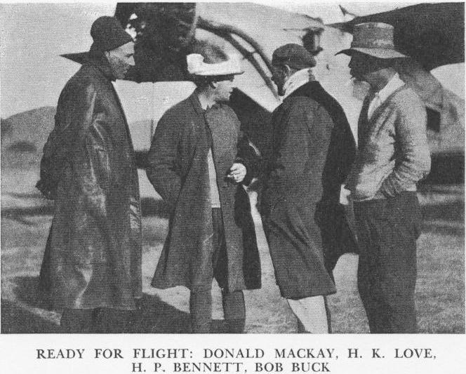
He contacted the Australian Aerial Services and hired two Anec
type aircraft. The area to be surveyed, was the South Western corner of
the Northern Territory. Captain Frank Neale and Captain H. B. Hussey were
the pilots. Commander Harry T. Bennett was the navigator and surveyor.
Mr. Howard Kingsley Love was the wireless operator. Mr. H. C. Morrison
was the photographer. The bushman Bob Buck proceeded out with 8 camels
and 5 natives to make a landing ground in the scrub. His daughter Effie
was the cook. An Afghan, Ali Mahomet took out 12 tons of stores, food and
petrol on 65 camels. The receiving equipment was required to cover the
short wave and the broadcast band. Harringtons Limited of Melbourne loaned
them a Pilot Super Wasp wireless receiver, which used plug in coils to change
bands. On the 24th of May 1930, Donald flew from Canberra, and arrived
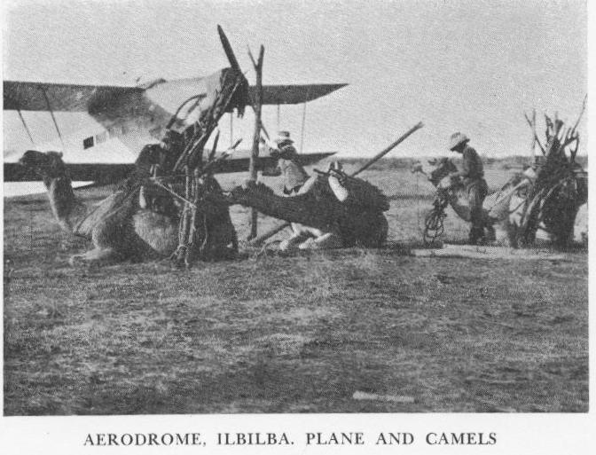
at Hermannsberg on 26th of May. One aeroplane stayed at Hermannsberg with
a wireless receiving set, and the other flew to Ilbilla, sending half
hourly signals. There seems to be three spellings of this place, and the
maps had it marked in different locations. At the main camp they received
wireless signals from the Melbourne Observatory and determined their position.
The receiver behaved erratically, until an empty petrol tin was buried in
the sand and kept wet. This counterpoise doubled the signal strength. The
airborne wind driven generator gave many problems and was stripped down
several times, as it was filling with soot from the engine exhaust. The
armature eventually failed. Love had borrowed a World War 1 hand crank
generator from VK3WG, for emergency use. It was made by Evershed and Vignoles
and generated 600 volts. This was used when airborne, and managed to produce
1/10th of an amp aerial current, which was considerably less than the 3/4
amp aerial current that the wind generator was able to produce. The aircraft
flew out on a fixed compass route, 130 miles from the camp, made a right
angled turn, then after 30 miles, turned back to camp. This was the maximum
range of the aircraft, so they had to be very careful, and expect no rescue
attempts. In the previous year, Kingsford Smith had made an emergency landing
in the desert, and two of the search party flying in the Kookaburra, had
perished in the desert. The radio and the camels were to assist if there
was any forced landing. They made 15 survey flights over 24 days. The expedition
corrected the size of Lake Amadeus from 200 miles long, to 58 miles long.
They also found a new previously unknown lake, which is the second largest
lake in Australia. It was named Lake Mackay. The expedition finished at
Adelaide on 28th June, and the next day was Donald's 60th birthday.
Henry Lewis Bell Lassiter heard about Donald's survey and asked
to be flown to the Petermann Ranges so that he could find and peg out
his "lost gold reef", three times bigger than the Kalgoorlie goldfields,
he said. There were no spare seats in the two Anec aircraft, so Donald declined
his request. In 1931 Lassiter made the newspaper headlines by getting lost
in the Petermanns while looking for his reef. Bob Buck searched for him
and found his body and his diary. Ian Idriess wrote the book "Lassiers's
Last Ride" about the lost reef.
1933 WESTERN AUSTRALIA
Donald planned a second aerial survey, and purchased a Percival Gull
aeroplane, with a greater range. They also took a De Havilland Moth piloted
by the owner Mr. T. Robertson. The area to be mapped was between Alice
Springs and Broome, flying from three bases, mostly in the Northern part
of Western Australia, at Docker Creek, Roy Hill and Fitzroy River. The same
personnel as before came on the expedition. Captain Frank Neale was the
pilot. Commander Harry T. Bennett was the navigator and surveyor. Mr. Howard
Kingsley Love was the wireless operator. The Civil Aviation Department
requested that exhaustive tests of wireless reception and transmission be
conducted under desert conditions. They loaned him an electrical power plant.
Donald supplied three transmitters and four receivers, including a short
wave experimental set, purchased from his own finances. Mr. J. Fuller was
added as a second wireless operator. Love built an airborne transmitter.
It was a simple and compact design, 13 inches by 7 inches with an internal
power supply. Visible on the outside was a single dial and a few terminals.
Inside were two 201A valves as oscillators, mounted on the rear of the
front panel. The power supply was an English ML generator providing 300
volts from 6 volts input, coming from an external 6 volt accumulator. It
was fitted to the Gull. The aerial was a wire stretched from wing tips to
the tail planes, and designed to work on 46 meters. No receiver was fitted
to the aircraft. Bob Buck set out to prepare the first base at Docker
Creek, took Dutchy as the camp cook, and J. Fuller to set up the wireless.
The aircraft left Sydney on 21st May 1933. There was a cyclone, and rain
was falling in the desert. On reaching Alice Springs they found that Mr.
Kilgariff, an amateur radio operator VKZ, had been in wireless contact with
Bob Buck's advance ground party. They flew the aircraft to the base and
began the aerial surveys. On 10th June, they flew 610 miles to the next
base at Roy Hill, losing wireless contact with Docker Creek after 350 miles.
The airborne wireless set had broken down. They conducted survey flights
around Roy Hill. On 22 June, they flew 450 miles to the third base at Fitzroy
River. They conducted further survey flights. On 28 June, they flew 580 miles
back to Docker creek. Even though the airborne wireless was not working,
the ground party had been carrying out wireless experiments with all parts
of Australia and overseas. They returned to Sydney on 16 July 1933.
Mackay criticised the harsh treatment of Aborigines, which was reported
in the British press in July 1933.
1935 WESTERN AUSTRALIA
Donald planned a third aerial survey and chartered a Monospar and
a Puss Moth aircraft. The area to be surveyed was in Western Australia,
North of the Tanscontinental railway line. The same personnel as before
came on the expedition. Captain Frank Neale and B. Shepherd were the pilots.
Commander Harry T. Bennett was the navigator and surveyor. This time, Captain
A. L. Wilkinson was the wireless operator. Harry Stone was the cook. Ali
Mahomet and Shir Mahomet left with camels, to become the emergency relief,
if needed. Donald left Sydney on 17 June 1935, arrived at Cook railway
camp on June 19, and began the survey flights to the North. They moved to
the second base at Forest railway camp on 27 June and continued the survey
flights. They moved to the third base at Rawlina railway camp on 6 July
and conducted more survey flights. They flew North West to the fourth base
at the Laverton gold fields on 11 July and continued the survey flights.
They returned East to the fifth base at Oodnadatta on 18 July, then back
to Sydney on 22 July 1935.
1937 NORTHERN TERRITORY
Donald planned a fourth aerial survey and chartered a twin engine
Dragonfly and a Puss Moth. The area was in the Western sector of the
Northern Territory. The same personnel as before came on the expedition.
Again Captain Frank Neale was the pilot. Commander Harry T. Bennett
was the navigator and surveyor. Expensive wireless equipment was purchased
and operated by W. Ferguson from Melbourne. In July, Bob Buck with his
camels, set out to prepare the ground base. Donald left Sydney on 19 July
1937 and arrived at Hermannsberg in the Northern Territory, then on to the
Tanami desert, where they made their aerial survey flights, and then some
more flights from Roy Hill, Fitzroy Crossing, and Wave Hill station. Their
wireless set in the aircraft, which cost 400 pounds, broke down. They arrived
back in Sydney on 27 August.
Donald Mackay was appointed the O.B.E. in 1934 and C.B.E. in 1937.
He died on 17 September 1958 at Sutherland Hospital.
POSTSCRIPT
HOWARD KINGSLEY LOVE
The wireless operator on the 1930 and 1933 expeditions, was Mr. Howard
Kingsley Love VK3BM. He was one of Australia's leading radio engineers,
an experienced pilot from the Great War, and held the rank of Flight-Lieut.
in the R.A.A.F. Mr. H. K. Love went on to found the Kingsley Radio Company
and produced the AR7 receiver for the R.A.A.F. The Kingsley company made
many other radio items, including Permaclad, Permacore and Ferrotune products.
GROUND BASE RADIO
The ground transmitter receiver used on the 1937 expedition, was donated
to Dick Smith by the Mackay family. It was designed by Don Knock VK2NO
(VK2NU portable), and manufactured by the Sterling Radio P/L Sydney.
REFERENCES:
Last of The Australian Explorers, Frank Clune, Angus and Robertson,
1942.
Radio on the Mackay Expedition, Don B. Knock, Australian Radio
News, May 26, 1933, pp 7, 39.
Photograph of transmitter, Knock, Love, Neale, and Robertson, with
Gull.
Photograph of Wireless Station at Docker Creek, Sydney Morning
Herald, 29 June 1933.
Visible are two people, generator, and wireless receiver.
Mackay Expedition emergency hand cranked generator, Radiold website.
(http://www.radiold.com/radios/radrare/radrare03.htm)
Radio Tests in Central Australia, H. K. Love, Listener In, 26 July
1930, pp 18, 19, 58.
(http://www.radiold.com/radios/radrare/listener_in01.jpg)
(http://www.radiold.com/radios/radrare/listener_in02.jpg)
(http://www.radiold.com/radios/radrare/listener_in03.jpg)
Dux bicycle, ridden around Australia by Donald Mackay, Power House
Museum, Registration number B583.
(http://www.powerhousemuseum.com/collection/)
Mackay Expedition 1930, Philip Crosby Morrison Guide to Records,
Series 11
(http://www.austehc.unimelb.edu.au/guides/morr/MORS0011.htm)
(http://www.asap.unimelb.edu.au/bsparcs/biogs/P000657b.htm)
The Mackay Aerial Survey Expedition, Central Australia,
May-June 1930, The Geographical Journal, Vol. 84, No.6 (Dec 1934),
pp 511-514.
(http://www.jstor.org/view/00167398/ap020504/02a00050/0)
D. Mackay papers (State Library of New South Wales).
Australian Dictionary of Biography
(http://www.adb.online.anu.edu.au/biogs/A100284b.htm)
Sydney Morning Herald, 1 Feb 1937
Papers received with 1937 transmitter and receiver, in possession
of Dick Smith VK2DIK.
Copyright Ray Robinson